Please use this identifier to cite or link to this item:
http://hdl.handle.net/10553/77757
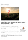
| Title: | Cómo creamos mapas inteligentes para planificar mejor los desplazamientos en la ciudad | Authors: | Abad Real, María Pilar | UNESCO Clasification: | 332506 Comunicaciones por satélite 54 Geografía |
Keywords: | Datos Transporte Movilidad urbana Geolocalización Islas Canarias, et al |
Issue Date: | 2021 | Journal: | The conversation | URI: | http://hdl.handle.net/10553/77757 | ISSN: | 2201-5639 | Source: | The Conversation [ISSN 2201-5639], 25 de enero de 2021 | URL: | https://theconversation.com/como-creamos-mapas-inteligentes-para-planificar-mejor-los-desplazamientos-en-la-ciudad-149211 |
| Appears in Collections: | Artículos |
Adobe PDF (1,97 MB)
Page view(s)
66
checked on Jun 3, 2023
Download(s)
76
checked on Jun 3, 2023

Google ScholarTM
Check
Share
Export metadata
Items in accedaCRIS are protected by copyright, with all rights reserved, unless otherwise indicated.