Identificador persistente para citar o vincular este elemento:
https://accedacris.ulpgc.es/jspui/handle/10553/75205
| Título: | Surface currents in the macaronesian region: thirteen years of drifting data | Autores/as: | Cardona, L.A. González, José A. Ortíz, V.M. Gelado Caballero, María Dolores Rueda López, Maria Jose Llinás Gonzalez, Octavio |
Clasificación UNESCO: | 3311 tecnología de la instrumentación 2510 Oceanografía |
Palabras clave: | Drifters Surface current Model Operational System |
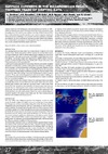
Fecha de publicación: | 2011 | Editor/a: | Universitat Politècnica de Catalunya | Publicación seriada: | Instrumentation viewpoint | Resumen: | More than 500 drifting buoys were deployed during the period of 1998 – 2010 in the Macaronesian region. The study of their trajectories has provided a good knowledge about the surface current system in this area. All this information has been implemented into a model intended to cover marine emergency situations in the Macaronesian archipelagos, such as search and rescue operations and pollut- ant dispersal. The aim is to develop an Operational System, based in the combina- tion of observations and analyses of oceanographic data with numerical simula- tion, in order to predict the drifting objects trajectories | URI: | https://accedacris.ulpgc.es/handle/10553/75205 | ISSN: | 1886-4864 | Fuente: | Instrumentation ViewPoint [ISSN 1886-4864], n. 11, p. 27 | URL: | http://dialnet.unirioja.es/servlet/articulo?codigo=7516361 |
| Colección: | Artículos |
Adobe PDF (218,35 kB)
Visitas
164
actualizado el 15-ene-2026
Descargas
64
actualizado el 15-ene-2026

Google ScholarTM
Verifica
Comparte
Exporta metadatos
Los elementos en ULPGC accedaCRIS están protegidos por derechos de autor con todos los derechos reservados, a menos que se indique lo contrario.