Please use this identifier to cite or link to this item:
https://accedacris.ulpgc.es/jspui/handle/10553/57364
| Title: | Evolución de la línea de costa de Tazacorte entre 1964 y 2015 (La Palma, Islas Canarias) | Other Titles: | Coastline evolution at Tazacorte between 1964 and 2015 (La Palma, Canary Islands) | Authors: | Marrero, Néstor Montoya Montes, Isabel Alonso Bilbao, Ignacio |
UNESCO Clasification: | 250607 Geomorfología | Keywords: | Pluviometry GIS Coastal geomorphology Las Angustias ravine Tazacorte port (La Palma, Canary Islands) |
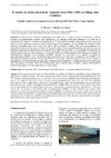
Issue Date: | 2017 | Journal: | Geotemas (Madrid) | Abstract: | Durante las cinco décadas comprendidas entre 1964 y 2015, la línea de costa de Tazacorte (La Palma,
Canarias) ha experimentado cambios muy significativos. La principal intervención antrópica en la zona fue la
construcción del puerto de Tazacorte en la década de los 70. Los procesos naturales determinantes en la zona son el
oleaje y la escorrentía que se produce a través del barranco de Las Angustias. Se han utilizado tres fuentes de datos
diferentes: fotografías aéreas de los años 1964, 1983 y 1989 y ortofotos de 2002 y 2015, datos pluviométricos para
caracterizar la escorrentía y datos de oleaje. Las fotografías aéreas fueron georreferenciadas y en todos los casos se
digitalizó la línea de costa mediante el uso de ArcGIS 10.4 (ESRI). De este modo se ha cuantificado la evolución de la
superficie de la playa a lo largo del tiempo, y se han relacionado los cambios espaciales observados con la creación de
infraestructuras antrópicas. Los principales resultados muestran un crecimiento en la superficie de playa de
aproximadamente 61000 m2
en el periodo de tiempo considerado lo que representa un volumen de unos 585000 m3
de
sedimentos acumulados en 50 años. El avance producido en la costa de Tazacorte evidencia dos hechos principales: la
dependencia de las infraestructuras humanas para la retención de los sedimentos y la importancia de la escorrentía en el
aporte de material a la playa. Todo ello ha determinado que la estrecha playa de cantos y bloques heterométricos
existente haya pasado a ser una amplia playa de arena y grava. During the five decades between 1964 and 2015, the coastline of Tazacorte (La Palma, Canary Islands) has suffered some significant changes. The main anthropic intervention was the construction of the port of Tazacorte in the 70’s. The determining natural processes in the area are the waves and the runoff that occur through the Las Angustias ravine. Three different data sources have been used: aerial photographs from 1964, 1983 and 1989 and ortophotos from 2002 and 2015, rainfall data to characterize the runoff and wave data. Aerial photographs were georeferenced and in all cases the coastline was digitized using ArcGIS 10.4 (ESRI). Thus, the evolution of the surface of the beach has been quantified and the spatial changes have been related to the creation of anthropic infrastructures. The main results show an increase in the beach surface of approximately 61000 m2 in the considered time period which represents a volume of accumulated sediments around 585000 m3 in 50 years. The progress made in the coast of Tazacorte shows two main facts: the dependence of the human infrastructures for the retention of the sediments and the importance of the runoff in the contribution of solid material to the beach. Those facts have determined that the boulder beach has become a wide sandy and gravel beach. |
URI: | https://accedacris.ulpgc.es/handle/10553/57364 | ISSN: | 1576-5172 | Source: | Geotemas ( Madrid ) [ISSN 1576-5172] (17), p. 247-250 | URL: | http://dialnet.unirioja.es/servlet/articulo?codigo=6398573 |
| Appears in Collections: | Actas de congresos |
Adobe PDF (952,08 kB)
Page view(s)
303
checked on Jan 16, 2026
Download(s)
388
checked on Jan 16, 2026

Google ScholarTM
Check
Share
Export metadata
Items in accedaCRIS are protected by copyright, with all rights reserved, unless otherwise indicated.