Please use this identifier to cite or link to this item:
https://accedacris.ulpgc.es/jspui/handle/10553/48536
| Title: | Study of mesoscale features and seasonal variability in the canary basin from GEOSAT, ERS-I and TOPEX/Poseidon altimeters data | Authors: | Tejera, A. García, L. Cantón, M. |
UNESCO Clasification: | 2510 Oceanografía 250616 Teledetección (Geología) |
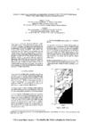
Issue Date: | 1997 | Publisher: | 0379-6566 | Journal: | European Space Agency, (Special Publication) ESA SP | Conference: | International Seminar on the Use and Applications of ERS in Latin America | Abstract: | Three series of altimeter data of the GEOSAT (1987-1989), ERS-1(1992-1993) and TOPEX/Poseidon satellites are used to identify and analyze the main mesoscale oceanographic features that appears in the oriental edge of the Atlantic Ocean, 20°-40° N, -19°- -9° W. The variability maps of the altitude of the sea surface and eddy kinetic energy have been computed by a process of objective analysis. Although the flow in this area is not so intensive as in the west frontier, like the Gulf Stream, it has been possible to compare the altimeter results with those from other remote sensing sensors and with in situ data. It has been estimated the correlation among the different types of data to detect eddies from the Mediterranean Sea and those generated in the south of Gran Canaria, as well as the identification of filaments from the NW African upwelling. | URI: | https://accedacris.ulpgc.es/handle/10553/48536 | ISSN: | 0379-6566 | Source: | Proceedings of an International Seminar on The Use and Applications of ERS in Latin America, Viña del Mar, Chile, 25-29 Noviembre 1996, European Space Agency, (Special Publication) ESA SP-405 [ISSN 0379-6566], p. 211-217 (Marzo 1997) |
| Appears in Collections: | Artículos |
Adobe PDF (395,41 kB)
Page view(s)
44
checked on Aug 12, 2023
Download(s)
12
checked on Aug 12, 2023

Google ScholarTM
Check
Share
Export metadata
Items in accedaCRIS are protected by copyright, with all rights reserved, unless otherwise indicated.